General Information
The Carretera Austral is a fantastic ride. It will bring you to one of the most beautiful places in South America. You have to bring a little bit of time with you though and be ready for some delay on the road. Another thing not to forget is proper rain gear. You will most likely see a lot of rain and heavy winds here.
There is lots of construction going on to turn this road from a dirt road into a good tarmac road. In many parts this has already been achieved, most of the road is still gravel. The majority of the gravel parts are in very good condition though. There are many people on regular bikes (e.g. choppers) on the road so it is not as bad as some people say. The construction sites are pretty bumpy though, so you have to take your time.
The Carretera Austral is a pretty young road. It was only in the seventies when the southern part of Chile was connected with a road. Chiles dictator Pinochet ordered to build the road to get easier access to it. Originally the roads name therefore was Carretera General Pinochet and was only changed later into the actual name Carretera Austral.
There is no lack of fuel here. You do not need more than 200km range on the Aarretera Austral.
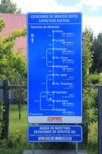
There are plenty of gas stations on the Carretera Austral, here is an overview of the Copec ones. There is a gas station between Coyhaique and Cochrane, it is just not a COPEC one.
But you need extra cash, since ATM are only available in a few towns (mainly in Coyhaique).
In the whole area there are lots of salmon farms. So if you like fish: this is where you probably get the best salmon.
Background:
We only rode the part from Hornopiren to LaJunta on motorbikes.
The part from LaJunta to Puyuhuapi and the most southern part from Cochrane to Villa O’Higgins I only know from describtion of other motorbikers which I interviewed in detail.
The part from Puyuhuapi to Cochrane we did on a 4×4 which we rented in Coyhaique.
Christy had an accident and broke her foot when we wanted to bypass Puyuhuapi since there was a larger landslide that completely blocked the road in December.
Getting there; the ferries:
The Carretera Austral is not connected to the rest of the Chilean road system. It is reached by the use of ferries.
There is a ferry going from the island of Chiloa. I have not found an actual timetable for it though. As far as I know they run once a week.
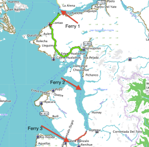
The main connection is by use of a total of three ferries.
You start the ferry connection in La Arena, 45km south of Puerto Montt. The ferries go every day every 45 minutes from 7:15am till 8:45pm. The duration is approx. 45minutes.
Motorbikes usually do not need a reservation, but of course you can do that if you want to be sure.
This ferry will bring you to a peninsula from which you continue on a partly paved road to Hornopiren.
In Hornopiren there are a couple of hostels, hotels and cabanas. The town has a nice flair and is nicely located at the end of a fjord.
From here Ferry two brings you from Hornopiren to Leptepu where you take a 10km dirt road to the next ferry. The loads of the two ferries are always connected so do not make a longer stop in between (thats not advisable anyway, since the road is terrible dusty). You will arrive at the third ferry after ten kilometers and you will be loaded on the third ferry which will bring you from fjord largo to Caleta Gonzalo.
The second ferry from Hornopiren leaves during highseason at 10am and at 12am. It takes approx. 3,5 hours.
After the short ride to ferry 3 you will immediatly boarded there.
The prices for ferry 2 and ferry 3 are connected, so you only pay on one of the two ferries. Ferry 3 is a 45 minutes crossing of a fjord.
You find the detailed ferry schedule, high- and lowseason prices more information here: http://www.taustral.cl
The homepage is in most parts spanish only.
The ferry rides are really nice. Since the bays are pretty protected there are no high waves. The ferries are all ex-marine landing boats, so they only have one ramp (meaning first-in last-out, and that means you have to turn your motorbike around for disembarking).
From disembarking of ferry 3 to Chaiten it is about 60km.
Take your time for this part. It leads through a fantastic national park with lots of green, nice views and ground zero of a desaster (the volcano Chaiten blew off with little warning in 2008).
There are a couple of campsites along the way and they are really nice, so if you own a tent, this is great camping here.
Chaiten has a couple of hostels and restaurants.
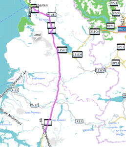
Chaiten to Puyuhuapi (187km)
The road from Chaiten to Puyuhuapi is again very nice. It starts as a well paved road and turns into a good gravel road after some 30km.
Between LaJunta and Puyuhuapi there is some construction going on. The road is closed between 1pm and 5pm, so make sure you are there before or after or take a book to read.
(Of course this construction is only temporarily, but from what we understood it will take some time, so check HU or ADV for update info on this).
In Puyuhuapi you will find many nice hostels, hotels and restaurants.
See our trip of this part here.
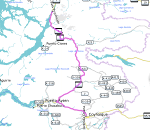
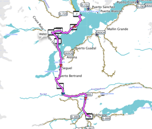
Puyuhuapi – Coyhaique (233km)
After Puyuhuapi make sure you take your time to go the Colgante glacier lookout. It is easily accesable and a great view. A few kilomters after the glacier there is a construction site again. The road is blocked from 1pm to 5pm (again check this for updates, search HU or ADV or ask the police, they know).
After an impressive and bumpy construction of approx. 5km the road gets better even though it is pretty bumpy with lots of potholes. You leave the fjord now. Enjoy the nature around you, it is beautiful.
12km after leaving the fjord you will hit a steep mountain pass. The road up is a bit bumpy in the curves. On the way down you will find the last 3 kilometers to be a construction site. This is probably the worst part of the whole Carretera Austral. Take it easy here.
You will find deep gravel with large rocks, all pretty steep and partly slippery. Go slow (unless you really know what you are doing in these conditions). It is only for a short distance.
Soon after the mountain pass the gravel road turns into a perfect tarmac road.
The road leads all the way to Puerto Aysen and from there to Coyhaique. There is a direct road shortcutting the road to Puerto Aysen. This shortcut is a very good gravel road.
Coyhaique is the biggest town on the Carretera Austral. It has lots of accomodation and a couple of good restaurants. Here is the only place where you can get securely cash on the Carretera Austral.
There is a surprisingly good hospital. They have good doctors and a very good x-ray machine (that’s what a swiss doctor said when he looked at Christy’s x-rays a few days later).
See our travel of this part here.
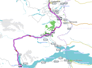
Coyhaique – Puerto Rio Tranquillo (220km)
The road is paved all the way to Cerro Castillo (100km). Cerro Castillo is a little town with some a restaurant and some simple hostels. You have a great view on the fantastic mountain that gives the name to the little town. The road till here is stunning and it is even getting better.
After Cerro Castillo the road turns into a gravel road. It is pretty good. Most difficult part in terms of riding is to keep the eyes on the road: the surrounding is one of the best areas I have seen in South America. The rivers and lakes have incredible colors, the nature is changing from really rich to some really brown parts.
The winds can be really strong here, so be ready to swerve over the road a little bit. If you feel exhausted think of the daredevils who ride this on bicycles. That will cheer you up!
In Rio Tranquillo there are a couple of restaurants and accommodation and a gas station. There are boat tours to the marble caves. In the morning the sun is shining into the caves, but you have to be lucky to have sun at all. The boat ride is pretty bumpy and you can get pretty wet (especially at the back of the boat).
One of the highlights on my entire SA trip was the boat trip to Laguna San Rafael. It is very pricy (around 200$ per person).
I have seen calving glaciers before (Iceland) and after (Perito Moreno). But this trip was fantastic and I highly recommend it to everybody. You need to ride yourself to the valley of Exploradores where the tour operator picks you up. The ride there itself is fantastic, so if you do not want to do the boat trip, at least have a little tour into the valley. It is really nice.
See our trip of this part here (1st part) and here (2nd part).
Puerto Rio Tranquillo – Cochrane (115km)
The road goes along the fantastic lake of General Carrera for some time. The color of the lake is fantastic and the road offers some nice views on it before it follows the Rio Baker south. The river cut a deep canyon into the mountains and so the road goes up and down following the river. Again the road is pretty good and only very few areas with a little bit deeper gravel are on the road. I general the road is in really good condition. It is getting narrower though.
Don’t miss the little hike to the junction of Rio Baker and Rio Nef (approx. here : S47° 06.902′ W72° 46.406′). There is a really nice waterfall there. A great place to do a little walk (it is only 15 minutes) and rest at the waterfall. The color of the Rio Baker is really strange and combines with the grey color of Rio Nef.
In Cochrane again you find nice accomodation, restaurants and a bank (even though I was not able to get money out of the ATM there).
See our trip experience of this part here (San Rafael) and here (road to Cochrane)
Cochrane – Villa o’Higgins
We did not do this part of the road, but I was told the road condition are even getting better. You have to ride this part of the track back though, since there is no way for motorbikers to continue to Argentina.
Cyclists can take a ferry and do a hike (pushing the bike) on a small, narrow trail. They take another ferry and end up close to Fitz Roy in Argentina. For motorbikers this does not seem to be an option.
Getting out:
There are multiple passes to or from Argentina:
From north to south:
- Futaleufu to Esquel (Ruta40): we did the road till Futaleufu (and from there we went back to the Carretera Austral). It is very nice and you end up in Esquel in Argentina, where you will also find multiple gas stations. Futaleufu is mainly known for massive class 5 whitewater rafting.
- Alton Palena – Carrenleufu – Tecka (Ruta40): (just south of Futaleufu) we did this after the Carretera Austral was blocked. The bordercrossing was simple and fast, the landscape on the Argentinian side is stunning. The road was mainly in good condition. There is a simple campsite in Tecka and the gasstation there has accomodation (4 appartments) which are nice and clean. In Tecka it gets pretty windy.
- La Junta – Lago Verde – Jose San Martin: we heard it is possible to cross there. We met one motorbiker who tried, but the rode was destroyed there because of a landslide (you may want to check with locals about the up-to-date road conditions.
- Coyhaique – Rio Mayo (Ruta40): we entered here from Argentina to Chile. On the way Christy had her accident. The road is quite difficult: deep gravel of large rocks. You either have to go very slow or go very fast. We both had a couple of “saves” before Christy couldn’t save it at one point. (see here). Rather difficult and not recommended.There are a few hotels in Rio Mayo, a gas station (only takes cash), a bank (we did not get any money though, thats an issue in Argentina and small towns in general).
- Puerto Ibanez – Chile Chico – Perito Moreno (Ruta 40): we only heared about this possibilty: many people use it, it is all paved, you can take a ferry to Chile Chico. Coming from north you miss nice parts of the Carretera Austral though
- Cochrane – Paso Roballos – Bajo Caracoles (Ruta40): this is a road leading through the property of the Tompkins. The “future National Park Patagonia”. A great landscape, many Guanacos, a nice visitor center of the NP already in place (worth a stop for a coffee). The road is stunning, but a bit bumpy at times, never difficult though. So just take your time. You can also go from a junction up north to Perito Moreno (must be nice, we didn’t see it). Anyway, a great ride. Bajo Caracoles has accomodation in the gasstation there. North of there there is the Cueva de los manos (see some pix here), a great site to visit. On the Ruta 40 you will have heavy winds. Read about our trip of this part here.

Pingback: Horizons Unlimited - The HUBB
Excellent write up of the route. Hopefully I can do the same after my visit and provide an update as to the conditions.
I’ll be taking it in early December so most of the construction will have changed by then.
I’ve heard that with December being just outside of the main season that the ferries might only be running once a day so I’ll have to watch out for that.
LikeLiked by 1 person
Thats great. You will have a great ride. I guarantee. :-))
LikeLike
Thank you for such a review!!! This is one of the most interesting reads on that wonderful road…
LikeLiked by 1 person
Hi Walter,
thank you very much. I am very pleased to hear that you enjoyed the read.
And thank you very much of letting me know.
All the best
Andy
LikeLike
Greetings from Los angeles! I’m bored at work so I decided to browse your website on my iphone during lunch break.
I enjoy the information you provide here and can’t wait to take a
look when I get home. I’m shocked at how fast your
blog loaded on my mobile .. I’m not even using WIFI, just 3G ..
Anyways, wonderful blog!
LikeLiked by 2 people
Glad you enjoyed it!
LikeLike
top hbb 4444444444444
LikeLiked by 1 person
Thanks. I appreciate it. Safe travels wherever you are…
LikeLike
I’m really enjoying the theme/design of your website. Do you ever run into any internet browser compatibility issues?
A number of my blog audience have complained about my website
not working correctly in Explorer but looks great in Safari.
Do you have any ideas to help fix this problem?
LikeLike