Chiloe

Island of Chiloe – Chile

Screen Shot 2015-02-17 at 21.31.56

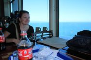
After we gave back our truck we stayed in a hostel for a week. It was very nice with a great view on the harbor of Puerto Montt where huge cruise ships anchored and big birds flew by our window every day.

Christy was getting better every day, but the doctor we visited here said she should rest another week before we can get back on the bikes.

After a few days I got bored and I decided to take the bike for a little spin on the Island of Chiloe.

So I packed some things together and rode on south to the short ferry crossing that would take me to Chiloe.

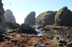
It was great to be back on the bike again. After the short ferry crossing I took the road to Ancud and further to a penguin colony. The ride was fantastic. A curvy road, the sun shining, little traffic and finally the rocky coast of the island. The road ended in a beach from where little boats take the tourists very close to the penguins. I decided not to join them and instead enjoyed the fantastic beach that ended on both sides in huge rock formations.

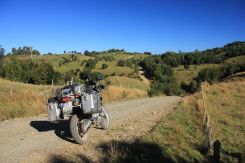
In kept going south and rode great gravel roads through forests and farming areas. All very nice and enjoyable. When I finally ended up in the little town of Castro I had a day full of great riding and I enjoyed a beer with some life music that was played in front of the colorful church of the town.

The next day I headed southwest to Culcao and Quilan. The road got a bit sandy and I enjoyed playing with the bike in the sandy bits. It was never difficult there though. The road ends at a parking spot from where you could hike 45 minutes to an outlook. The guard at the parking told me I may go there by bike that I intended to do immediately. The track was wide in the beginning and easy, but soon it turned into a very steep narrow track with big steps. It was great fun to ride it, but it would be unnerving if I met hikers on this track. There was no way to bypass hikers. So after a while I turned around and rode the steep track down again.

The landscape was incredible. The steaming and roaring sea covered the coast in a mist of salty water. Steep cliffs and flat sand beaches formed the coast. Riding was a blast and so I returned back to the north with a big smile on my face.

Short stops at some of the beautiful wooden churches contributed to these great days I had on that island. It is really great motorbike country here.

A perfect day

We’d been riding two days in cold pouring rain, followed by one with sidewinds and gusts of up to 80 km/h. At least our clothes were finally dry and it was a relief to get out on the road in fair weather again.

What made this day seem perfect: the previous three days

The Carretera Austral is a picturesque and special road, with mountains, fjords and glaciers all around. It is connected by ferries to the regular Chilean road system and in this region, it is the only north/south road. They say if you are trying to go fast, you won’t get far. You have to take it easy and go with the flow here. The conditions of the road seem to have changed a lot according to accounts I’ve read. It’s in pretty good condition and improvements are continuously underway.

We left the Carretera Austral briefly on a little jaunt out to see Futaleufu and back, but as we returned and continued south, we were warned by oncoming travellers of a roadblock ahead. It’s normal to expect construction and even regular daily closing times in some sections. This one, however was different. There was a rockslide and no one knew how long the closure would last. It would only be possible to open again if the rain would let up and that didn’t look likely for a few more days. We decided to track back again, covering the road off to Futaleufu a third time in order to cross over to Argentina and continue south a bit. We would cross back over to the Carretera Austral at the next chance.

Our detour took us through the unremarkable Argentine towns of Tecka and Rio Mayo. The ride between these two places was paved but quite often difficult. Westerly winds swept us into a slanted position all day. It was a bit unreal. We had experienced strong winds in the desert and on the coast of Peru, but in this vast open flatness, the wind seemed even more brutal. Whoever rode second got the best view of how crazy the wind was and that’s how Andy saw me leaning just a little bit to the right in order to make the left curve. Luckily there were few curves and even less passing to do. The gusts just made it very tiring. Rio Mayo was our first chance to cut back over to the Carretera Austral and we took it. I was eager to get back to that beautiful, enjoyable, legendary road.

A perfect start

The route from Rio Mayo, Argentina over to Coyhaique, Chile isn’t paved and it promised to be a long afternoon of dust and gravel. Despite sleeping in what might has well have been a jail cell (seriously, we had view of a bricked in-window). I was in a great mood, happy to return to one of our trip’s highlights. We didn’t know yet where we’d be for the holidays and with all this warmth and sunshine, it wasn’t feeling much like Christmas, but for some reason I was giddy, singing carols anyway.

The road required a lot of concentration, because it changed quite quickly and unexpectedly. Some parts were just normal gravel, some a bit deeper with big grooves to navigate, but some areas were very surprising layers of large rocks piled up on one another. I found the best way to deal with these surprise patches was similar to how I managed the slipperiness of sand: roll on the throttle a bit, lean back and get it steady. The bike might swerve a little right and left, but we mostly had the road to ourselves, so there was nothing to fear really. It was working out well and this day seemed perfect.

It was about halfway to Coyhaique that my bike became unstable, I couldn’t make the save and I fell. It happened really quickly, a right-left-right-left over big smooth rocks and I about had it, but then it seems hit the one rock in the road which wasn’t moving, my steering turned and I was sliding sideways on the right side with my foot pinned under the bike. My leg was turned back, my foot was being dragged under the foot peg and I had a pain in my foot which I knew wasn’t good. I remember thinking that this would have to change soon, I couldn’t take this position much longer. About then, the bike popped up for a split second, my foot was freed, a 180 degree turn was completed and the bike bounced from the right pannier, then landed on the left and that was it.

I got off the bike and just wanted to remove my boot. I poured some water on my foot and laid some of the cold rocks around it for a few minutes. It hurt badly and it was swelling, but I could still wiggle my toes, so I assumed it wasn’t broken. I had never broken any bones. The leather on the front top of boot around the big toe was badly scuffed, so I thought maybe it was just a bad sprain from the twisting.

We had about another 100 km to go in either direction. Return to Rio Mayo? I couldn’t even think of going back over that horrible stretch of road again. Coyhaique is sort of isolated over on the Carretera Austral, but it should be a town big enough to have whatever we need, so I wanted to continue on.

Riding was tough. Singing helped. Standing was difficult, only possible if I put most of my weight on the left foot and only had my heel on the right peg. When sitting, I could kind of brace myself and hold my right leg out away from the bike to avoid feeling the big bumps. Stopping at the boarder crossings and trying to walk was the incredibly painful part. Walking was not working. Soon though, there was paved road into Coyhaique, at least it was a smooth ride for a little while.

Andy did the checking in at a hostel. Our room was upstairs. I was moving slowly, not knowing how exactly to get up there. The receptionist looked at me strangely and asked if I was sick as I hobbled sideways up the steps. “Si, un poco.” I didn’t have words to explain in any language, I just wanted to finally lay down and call it a day.


3P-Info Part: Carretera Austral

General Information

The Carretera Austral is a fantastic ride. It will bring you to one of the most beautiful places in South America. You have to bring a little bit of time with you though and be ready for some delay on the road. Another thing not to forget is proper rain gear. You will most likely see a lot of rain and heavy winds here.

There is lots of construction going on to turn this road from a dirt road into a good tarmac road. In many parts this has already been achieved, most of the road is still gravel. The majority of the gravel parts are in very good condition though. There are many people on regular bikes (e.g. choppers) on the road so it is not as bad as some people say. The construction sites are pretty bumpy though, so you have to take your time.

The Carretera Austral is a pretty young road. It was only in the seventies when the southern part of Chile was connected with a road. Chiles dictator Pinochet ordered to build the road to get easier access to it. Originally the roads name therefore was Carretera General Pinochet and was only changed later into the actual name Carretera Austral.

There is no lack of fuel here. You do not need more than 200km range on the Aarretera Austral.
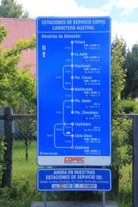
There are plenty of gas stations on the Carretera Austral, here is an overview of the Copec ones.

There are plenty of gas stations on the Carretera Austral, here is an overview of the Copec ones. There is a gas station between Coyhaique and Cochrane, it is just not a COPEC one.

But you need extra cash, since ATM are only available in a few towns (mainly in Coyhaique).

In the whole area there are lots of salmon farms. So if you like fish: this is where you probably get the best salmon.


Background:

We only rode the part from Hornopiren to LaJunta on motorbikes.

The part from LaJunta to Puyuhuapi and the most southern part from Cochrane to Villa O’Higgins I only know from describtion of other motorbikers which I interviewed in detail.

The part from Puyuhuapi to Cochrane we did on a 4×4 which we rented in Coyhaique.

Christy had an accident and broke her foot when we wanted to bypass Puyuhuapi since there was a larger landslide that completely blocked the road in December.


Getting there; the ferries:

The Carretera Austral is not connected to the rest of the Chilean road system. It is reached by the use of ferries.

There is a ferry going from the island of Chiloa. I have not found an actual timetable for it though. As far as I know they run once a week.

The main connection is by use of a total of three ferries.

You start the ferry connection in La Arena, 45km south of Puerto Montt. The ferries go every day every 45 minutes from 7:15am till 8:45pm. The duration is approx. 45minutes.

Motorbikes usually do not need a reservation, but of course you can do that if you want to be sure.
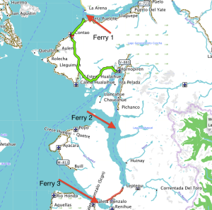
The three ferries

The three ferries

This ferry will bring you to a peninsula from which you continue on a partly paved road to Hornopiren.

In Hornopiren there are a couple of hostels, hotels and cabanas. The town has a nice flair and is nicely located at the end of a fjord.

From here Ferry two brings you from Hornopiren to Leptepu where you take a 10km dirt road to the next ferry. The loads of the two ferries are always connected so do not make a longer stop in between (thats not advisable anyway, since the road is terrible dusty). You will arrive at the third ferry after ten kilometers and you will be loaded on the third ferry which will bring you from fjord largo to Caleta Gonzalo.

The second ferry from Hornopiren leaves during highseason at 10am and at 12am. It takes approx. 3,5 hours.

After the short ride to ferry 3 you will immediatly boarded there.

The prices for ferry 2 and ferry 3 are connected, so you only pay on one of the two ferries. Ferry 3 is a 45 minutes crossing of a fjord.

You find the detailed ferry schedule, high- and lowseason prices more information here: http://www.taustral.cl

The homepage is in most parts spanish only.

The ferry rides are really nice. Since the bays are pretty protected there are no high waves. The ferries are all ex-marine landing boats, so they only have one ramp (meaning first-in last-out, and that means you have to turn your motorbike around for disembarking).

From disembarking of ferry 3 to Chaiten it is about 60km.

Take your time for this part. It leads through a fantastic national park with lots of green, nice views and ground zero of a desaster (the volcano Chaiten blew off with little warning in 2008).

There are a couple of campsites along the way and they are really nice, so if you own a tent, this is great camping here.

Chaiten has a couple of hostels and restaurants.


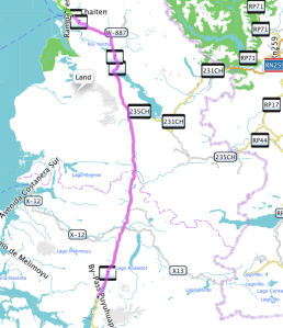
Chaiten to Puyuhuapi (187km)
Chaiten - Pyuhuapi

Chaiten – Pyuhuapi


The road from Chaiten to Puyuhuapi is again very nice. It starts as a well paved road and turns into a good gravel road after some 30km.

Between LaJunta and Puyuhuapi there is some construction going on. The road is closed between 1pm and 5pm, so make sure you are there before or after or take a book to read.

(Of course this construction is only temporarily, but from what we understood it will take some time, so check HU or ADV for update info on this).

In Puyuhuapi you will find many nice hostels, hotels and restaurants.

See our trip of this part here.

Puyuhuapi – Coyhaique (233km)
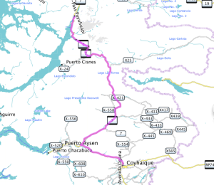
Puyuhuapi - Coyhaique

Puyuhuapi – Coyhaique


After Puyuhuapi make sure you take your time to go the Colgante glacier lookout. It is easily accesable and a great view. A few kilomters after the glacier there is a construction site again. The road is blocked from 1pm to 5pm (again check this for updates, search HU or ADV or ask the police, they know).

After an impressive and bumpy construction of approx. 5km the road gets better even though it is pretty bumpy with lots of potholes. You leave the fjord now. Enjoy the nature around you, it is beautiful.

12km after leaving the fjord you will hit a steep mountain pass. The road up is a bit bumpy in the curves. On the way down you will find the last 3 kilometers to be a construction site. This is probably the worst part of the whole Carretera Austral. Take it easy here.

You will find deep gravel with large rocks, all pretty steep and partly slippery. Go slow (unless you really know what you are doing in these conditions). It is only for a short distance.

Soon after the mountain pass the gravel road turns into a perfect tarmac road.

The road leads all the way to Puerto Aysen and from there to Coyhaique. There is a direct road shortcutting the road to Puerto Aysen. This shortcut is a very good gravel road.

Coyhaique is the biggest town on the Carretera Austral. It has lots of accomodation and a couple of good restaurants. Here is the only place where you can get securely cash on the Carretera Austral.

There is a surprisingly good hospital. They have good doctors and a very good x-ray machine (that’s what a swiss doctor said when he looked at Christy’s x-rays a few days later).

See our travel of this part here.

Coyhaique – Puerto Rio Tranquillo (220km)
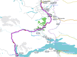
Coyhaique - Puerto Rio Tranquillo

Coyhaique – Puerto Rio Tranquillo


The road is paved all the way to Cerro Castillo (100km). Cerro Castillo is a little town with some a restaurant and some simple hostels. You have a great view on the fantastic mountain that gives the name to the little town. The road till here is stunning and it is even getting better.

After Cerro Castillo the road turns into a gravel road. It is pretty good. Most difficult part in terms of riding is to keep the eyes on the road: the surrounding is one of the best areas I have seen in South America. The rivers and lakes have incredible colors, the nature is changing from really rich to some really brown parts.

The winds can be really strong here, so be ready to swerve over the road a little bit. If you feel exhausted think of the daredevils who ride this on bicycles. That will cheer you up!

In Rio Tranquillo there are a couple of restaurants and accommodation and a gas station. There are boat tours to the marble caves. In the morning the sun is shining into the caves, but you have to be lucky to have sun at all. The boat ride is pretty bumpy and you can get pretty wet (especially at the back of the boat).

One of the highlights on my entire SA trip was the boat trip to Laguna San Rafael. It is very pricy (around 200$ per person).

I have seen calving glaciers before (Iceland) and after (Perito Moreno). But this trip was fantastic and I highly recommend it to everybody. You need to ride yourself to the valley of Exploradores where the tour operator picks you up. The ride there itself is fantastic, so if you do not want to do the boat trip, at least have a little tour into the valley. It is really nice.

See our trip of this part here (1st part) and here (2nd part).

Puerto Rio Tranquillo – Cochrane (115km)
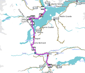
 

Rio Tranquillo - Cochrane

Rio Tranquillo – Cochrane

The road goes along the fantastic lake of General Carrera for some time. The color of the lake is fantastic and the road offers some nice views on it before it follows the Rio Baker south. The river cut a deep canyon into the mountains and so the road goes up and down following the river. Again the road is pretty good and only very few areas with a little bit deeper gravel are on the road. I general the road is in really good condition. It is getting narrower though.

Don’t miss the little hike to the junction of Rio Baker and Rio Nef (approx. here : S47° 06.902′ W72° 46.406′). There is a really nice waterfall there. A great place to do a little walk (it is only 15 minutes) and rest at the waterfall. The color of the Rio Baker is really strange and combines with the grey color of Rio Nef.

In Cochrane again you find nice accomodation, restaurants and a bank (even though I was not able to get money out of the ATM there).

See our trip experience of this part here (San Rafael) and here (road to Cochrane)

Cochrane – Villa o’Higgins

We did not do this part of the road, but I was told the road condition are even getting better. You have to ride this part of the track back though, since there is no way for motorbikers to continue to Argentina.

Cyclists can take a ferry and do a hike (pushing the bike) on a small, narrow trail. They take another ferry and end up close to Fitz Roy in Argentina. For motorbikers this does not seem to be an option.


Getting out:

There are multiple passes to or from Argentina:

From north to south:

  1. Futaleufu to Esquel (Ruta40): we did the road till Futaleufu (and from there we went back to the Carretera Austral). It is very nice and you end up in Esquel in Argentina, where you will also find multiple gas stations. Futaleufu is mainly known for massive class 5 whitewater rafting.
  1. Alton Palena – Carrenleufu – Tecka (Ruta40): (just south of Futaleufu) we did this after the Carretera Austral was blocked. The bordercrossing was simple and fast, the landscape on the Argentinian side is stunning. The road was mainly in good condition. There is a simple campsite in Tecka and the gasstation there has accomodation (4 appartments) which are nice and clean. In Tecka it gets pretty windy.
  1. La Junta – Lago Verde – Jose San Martin: we heard it is possible to cross there. We met one motorbiker who tried, but the rode was destroyed there because of a landslide (you may want to check with locals about the up-to-date road conditions.
  1. Coyhaique – Rio Mayo (Ruta40): we entered here from Argentina to Chile. On the way Christy had her accident. The road is quite difficult: deep gravel of large rocks. You either have to go very slow or go very fast. We both had a couple of “saves” before Christy couldn’t save it at one point. (see here). Rather difficult and not recommended.There are a few hotels in Rio Mayo, a gas station (only takes cash), a bank (we did not get any money though, thats an issue in Argentina and small towns in general).
  1. Puerto Ibanez – Chile Chico – Perito Moreno (Ruta 40): we only heared about this possibilty: many people use it, it is all paved, you can take a ferry to Chile Chico. Coming from north you miss nice parts of the Carretera Austral though
  1. Cochrane – Paso Roballos – Bajo Caracoles (Ruta40): this is a road leading through the property of the Tompkins. The “future National Park Patagonia”. A great landscape, many Guanacos, a nice visitor center of the NP already in place (worth a stop for a coffee). The road is stunning, but a bit bumpy at times, never difficult though. So just take your time. You can also go from a junction up north to Perito Moreno (must be nice, we didn’t see it). Anyway, a great ride. Bajo Caracoles has accomodation in the gasstation there. North of there there is the Cueva de los manos (see some pix here), a great site to visit. On the Ruta 40 you will have heavy winds. Read about our trip of this part here.

Snap!

Carretera Austral – Tecka – Rio Mayo – Coyhaique

Screen Shot 2015-01-09 at 00.31.41 Screen Shot 2015-01-09 at 00.19.48

I just saw a cloud of dust in front of me. Christys bike slid on the right side. Somehow she managed to be still on the bike. With a little pirouette the bike bounced to the left side and Christy finally crawled away from the bike.

This all happened very quickly right in front of me. It looked painful.

I slammed the brakes and ran to her to see whether she’d be ok…


The road led from Rio Mayo in Argentina back into Chile to Coyhaique. We had to make a detour via Argentina as the Carretera Austral was blocked due to a landslide. There were only two options: wait for a few days or make the detour. With the pouring rain we had in Chile the decision was made quickly. We rode across to Argentina, stayed the night in Tecka and went down the paved Ruta 40 till Rio Mayo, where we found a little hotel. From there it would be only going straight west back to Coyhaique in Chile. So this was how we ended up on this road

The road from Rio Mayo was enjoyable, but it was difficult to ride on. I followed Christy and could see how her bike bouncing underneath her quite wildly at times.

But she did well, and looked quite relaxed on the bike. The road consisted of deep gravel with stones as big as my fist. The only way to get through there is either very slow or with some speed. We felt comfortable to go with 60km/h and that turned out to be a good speed. You had to be very concentrated though, since the gravel was soft at times and piled up to deep ruts. We rode this road for 2 hours before the accident happened.

Christy was surprisingly pretty relaxed. Her right foot hurt badly, but after a while sitting on the ground she decided she could go on. I can’t believe how tough she is. We continued on the road for another 60km before we reached the Chilean border. The road got a lot better and we found a nice hostel in Coyhaique where Christy laid down. The foot has swollen quite a bit and she was in pain.

The next day we went to the hospital to make sure nothing has been broken and to get some medicine.

She got an x-ray and the doctor opened the news on the screen very frankly: 2 broken metatarsals (2nd and 3rd). No walking, not to mention riding a bike off-road for min. 6 weeks.

We had to do some re-planning…


Into the rain

Chaiten – Futaleufu- La Junta – Palena

Screen Shot 2015-01-09 at 00.14.51 Screen Shot 2015-01-09 at 00.14.21

We started out of Chaiten in sunny weather. The paved road followed a valley with spectacular mountains. After 30km the road turned into a very well maintained gravel road and we enjoyed riding quite a lot.

We heared of the town of Futaleufu which was supposed to be real nice. So we turned off the Carretera Austral to ride the 100km up the mountains. A fantastic scenery was the reward for this little detour. The town is known mainly for its class 5 whitewater rafting and so you see a lot of wild rivers along the way.

The town itself was not as enjoyable as we thought, but we were compensated with an incredible sky that was illuminated in the wildest and most intense colors at sunset.

The following day was cloudy and soon after we started on the motorbikes it started raining. And it wouldn’t end that day. We rode down the road we already knew back to the Carretera Austral in pouring rain, it got cold and so we were happy to find a cafe where we could warm up a little bit.

Soon after our break we where stopped by a motorbiker who came the other direction. He told us that the road was blocked and that the only options would be to wait until the landslide was removed or to go around it via Argentina. We stood there in the pouring rain, checking the options and finally decided that waiting wouldn’t be what we wanted to do. So we turned around and rode the road back again.

We found a nice little Bed&Breakfast where we stopped for the night. With a warm oven and a great meal in our stomachs we slowly warmed up.

The following day we would cross the border to Argentina, and again we started in the rain and it would rain until we hit the border. It was miserably cold…

3P-Info Part: Salar de Uyuni

The Salar de Uyuni is one of the most amazing places I have ever visited.

Crossing it on a motorbike is priceless. Don’t miss it.

Get there:

To get to Uyuni from LaPaz there are basically two options:

1. direct road from Challapata to Uyuni

2. continue in Challapata on the Ruta 1 to Potosi and then go west to Uyuni.

The first option is a really bad road. Lots of cur rogations, sandy parts, lots of construction. They are building a new road, so in a few months this might be a good option. But certainly till middle of 2015 this is a very bad road for 160km. But it is very beautiful and there a nice spots to pitch your tent on the way (eg. rock formations few km before Rio Mulatos).

The second option is all paved and in good conditions. Potosi seems to be a nice city with a silver mine. So this is by far the easier route.

It case in rains:

In case it had rained, it is strongly recommended (by a lot of people, including local guides and international motorbike guides) to not enter on your own motorbike. That is especially the case for modern motorbikes with a lot of electronic equipment. The water splashes everywhere and may cause serious problems. After a day, or a week or a month…

When the lake is whet (in ourcaseonly the first few hundret meters) the salt really gets everywhere.

Some people had to leave their motorbike there as the electrics got so badly torn up, that it was not repairable. Of course you can also go with your own bike if it is wet, if you are lucky you won’t have any problems.

You can rent motorbikes though (small Honda 400ccm which are big fun or more powerful DR650).

You can rent them at MTB: http://www.motorcycletoursuyuni.com

They only rent including guide at 200$ per day. Thats quite pricy, but totally worth it. The alternative would be to take one of the many 4×4 organised tours. That is a lot cheaper, but you miss the feeling of riding a motorbike on the salar, which is fantastic.

If the Salar is dry it is safe to go on your own bike

Ride into the void:

There are only few places where you can enter the Salar.

Don’t enter anywhere else and only use the tracks from the 4×4. Off the tracks the surface can be very soft so that you may sink your bike and need a 4×4 to pull it out.

The eastern entrance is in Colchani at the road from Chalapata to Uyuni at approx. 20km north of Uyuni (S20° 17.876′ W66° 56.130′). You can’t miss it. There are 2 salt hotels at the entrance. We haven’t stayed there, but people we met said it was interesting (plus you can see the sunset over the salar there).

Once you are on the Salar you can go wherever you want.

Once in the while little holes (up to 50cm diameter) offer a view into the world of salt crystals underneath (the locals call them “Ojos”). They are no danger and you can go and have a look.

There is an island where all the 4×4 organized tours go to (S20° 14.498′ W67° 37.671′): Isla Incahuasi (formerly Isla Pescado). It has a little hill and offers a fantastic view. Only enter the island from the northeastern end (where you will see some huts and during the day dozens of 4×4, as the rest of the surroundings of the islands may have a thin salt crust).

It is great fun to ride the bike on the Salar. It is not slippery at all.

After the visit make sure to clean your bike at one of the many washing places in town.

3P – Info Part: Southwest Bolivia – Laguna Colorada

Uyuni to San Pedro de Atacama

Riding north to south it seems a logical route to go from Uyuni to San Pedro de Atacama in Chile. It is fantastic ride, don’t miss it.

Here are some pictures from our trip.

Below there is some information about the ride. But first let me give you some general information:

The internet is full of reports about this area. A lot of people who did the ride had a hard time and that’s what they write. Don’t hesitate of doing it though.

With the right preparation everybody can do it on every bike (maybe not a Goldwing or a racebike).

Update: after I got an email of Bob, a great fellow, aged 74, who asked me about some details I would like to add one more sentence here: if you are not an experienced off roader, you have to be prepared to pick up your bike a few times. Little falls just may happen. At altitude of constantly over 4000m (13000ft) and at times over 5000m (16000ft) that might be strenuous. Take your time, take it easy and you are fine though.

We did it on a F650GS Dakar and a G650GS. We had Heidenau tyres which were quite low on profile.

My girlfriend made her license not a year before the trip. She had little experience before the trip and one long weekend offroading with a little Beta200. So you don’t need to be an expert at all. Just prepare and take it easy.

What you need is:

  • Fuel for 500km (we simply bought two 5L fuel cans that we strapped on the bike)
  • Enough water (we had 4L each)
  • Some money for the overnight stays (be reminded that you enter a national park where you have to pay 150Bs entrance).
  • Some snacks to keep you going during the day
  • GPS maps of the area (OSM has a good map which turned out to be very precise in this area). (The paper maps from Reise-Know-How are crap for this part of the journey).

Take your time. We made it in 3 days, which was quite relaxing.

Don’t be worried if something happens: There are many 4×4 running these roads as this is a very common touristic thing to do in organized tours (see below), so there is always help if needed. People will stop when you give them a sign. You can also ask them if you are unsure about directions. Just stop an wait a little bit. There will be someone coming.

The most4x4 tours make the loop: Uyuni-Salar-San Juan-Laguna Colorada- Laguna Verde- Villa Mar-San Cristobal-uyuni(3 days).

The 3 options:

There are basically 3 ways from Uyuni to San Pedro de Atacama.

  1. The Lagoon route via San Juan
  2. The route via San Cristobal
  3. The route via Tupiza
  1. The lagoon route is the by far most sandy one. It has a stretch of more than 60km (depending on the conditions up to 90km) sand. You pass a lot of lagoons and this is the route the 4×4 take from Uyuni via San Juan to the Laguna colorado all along the Chile-Bolivia border. You also pass the famous Arbol de Piedra, a rock formation that looks like a tree. For motorbikers this is the most strengous version.
  1. San cristobal route: This route is the one we took. It seems to be the easiest one. The first bit is in very good condition (almost like a paved road) and there are only short sandy bits of road (max. 1km). Most parts of the road are rocky and easy to ride. You pass a nice lagoon and some incredible rock formations that are certainly as spectacular as the Arbol de piedra. You can devide the road in 3 days or do it in 2 days (but that would be pretty hard or you are experianced off roader).
  1. The route via Tupiza is also pretty sandy, not as much as the Lagoon route (I was told by a 4×4 tourguide). It brings you to places where Butch Cassidy and Sundance Kid lived and died. This route I have the least information on, but for people who are experianced offroaders and who want to spend some more remote time this would be the route. There are not as many 4×4 tours on this road.

Info Laguna Colorada

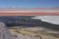
Flamingos, thousands.

Flamingos, thousands.

Route 1 and 2 are meeting at the Laguna Colarada.

There is a camp there (S22° 10.260′ W67° 49.049′) where all the 4×4 groups stay. Simple rooms usually as dorms, but you can also rent a complete dorm for yourself if you want to have some privacy.

There is another one (calls himself a hotel, but is not better than the camp(Info from a 4×4 tour guide) south of the Laguna Colorada (S22° 15.802′ W67° 48.961′). Here you can also buy water and snacks.

Close to the camp there is a lookout (S22° 10.222′ W67° 48.279′).

DO NOT MISS THAT. If you are doing route 2 go around the laguna (or take a short cut on the north side of the laguna) and go there. All the tourists go there so the place gets crowdie at times, but this place is incredible. The colors of the lagunas are in general better in the afternoon, as the strong afternoon winds stir up the water and the bacteria in it which create the great color

 Detailed describtion of Route 2:

Uyuni – San Cristobal – Villa Mar – Laguna Colorada – Camp Laguna Colorada – Geysers – Laguna Verde

The road leaves Uyuni south west direction. You pass a gas station (S20° 28.174′ W66° 49.200′) and leaving the town. The road is in very good condition. You can easily go 80km/h. In San Cristobal there is a gas station, but it does not always have fuel. So don’t count on it. But if you have very little reserve, you can try to get some fuel here.

There are also some shops where you can get water.

Shortly after the town of Villa Alota take a left (at S21° 23.974′ W67° 36.893′).

The road gets rougher now. A little bit of dust and sand is on the rocky road, so take it easy. Shortly after the turn off there is a water crossing. It is approximately 40cm deep and rocky. So you may get your feet wet. They are building a bridge there, so end of 2014 you may have a less adventurous crossing there.

The road gets up the mountain and soon you will see amazing rock formation right next to the road on your right hand side (S21° 32.155′ W67° 34.742′). If you plan to camp, this is an excellent place.

IMG_4103 copy

The following part of the road is a bit sandy at parts, but never long stretches. And the sand is never really deep. So you can “powerwalk” through the sandy parts.

In Villa Mar there are a couple of simple B&B. The tours stop here on the way home from the Laguna Verde. We stayed here in a simple B&B at the end of the town and had a great meal in the evening and a good (simple) breakfast. You can also buy water here.

Shortly after Villa Mar you have to turn off the main road. The turn off is here (S21° 46.208′ W67° 27.818′).

IMG_4147 copy

Turn to the right and follow up the hills into a beautiful little valley which I like to call “Lama paradise”. If you get there, you know why. The road gets pretty rocky here.

After a few kilometers you arrive at the first lagoon (Laguna Capina). You have a nice view on it. So make a break and enjoy the view.

A first lagoon

A first lagoon

After you have the lagoon behind you a pretty sandy strech begins. It is pretty much the worst part and it will bring you into the national park. There is a guy living here in a small hut. You have to pay him some money and you get a ticket. Don’t loose it. It will be checked on the way out (some told us, we were not checked).

Shortly after the entrance of the national park you hit another junction. You have to take a right here. The main road is where most of the 4×4 tours come back from Laguna Verde directly. So following the main road means you miss Laguna Colorada (and you don’t want to miss that!). If you have doubts, wait until the next 4×4 arrives, stop him and ask for directions. I think the junction is approx. here (S22° 09.125′ W67° 39.732′).

This will bring you to the laguna colorada. Don’t miss the viewing point (S22° 10.222′ W67° 48.279′) and stay a night here. Watch out, the way from the camp to the lookout is best on foot (500m from the camp). The road there is really really sandy. (deep sand).

It is worth it. Going around the laguna is pretty sandy. There is a track right north of the lagoon. I have not checked it out, but it would be worth a try. It would be a lot shorter than around the lagoon. (More info see chapter INFO Laguna Colorada)

The bit around the Laguna is pretty sandy.

The bit around the Laguna is pretty sandy.

After a cold night at the Laguna Colorada the road goes up the mountain. As soon as you have left the laguna the sandy bits are over. No more sand.

Leaving the Laguna Colorada up the mountain.

Leaving the Laguna Colorada up the mountain.

There is the Aduana (S22° 26.454′ W67° 48.357′) but you DO NOT NEED to go there You can do the customs directly at the border since 2014!

There are some geysers (S22° 26.002′ W67° 45.696′) and they are most active in the morning. So 4×4 tours start at 4am. We took it more easy and it was still impressive.

You pass another laguna (Laguna Chelviri) with hot springs. At the hot springs there is a little shop and you will find dozens of 4×4 from organized tours.

Shortly after that on your left hand side there is a fantastic rock formations on complete flat sand. For a reason this is called Disierto Salvador Dali. Its quite nice.

Finally the road leads between the Laguna Verde and the Laguna Blanca. Its a real highlight (S22° 47.292′ W67° 49.067′).

The Laguna Verde. The strong and cold wind stirred up the colourful lagoon.

The Laguna Verde. The strong and cold wind stirred up the colourful lagoon.

The road goes along the south side of the Laguna Blanca and is a bit soft (the road on the north side is a bit better id guess), but no bigger problem. Just take it easy. It is not far to tarmac anymore.

The border is not far away, just up the hill (approx. S22° 52.434′ W67° 47.426′). Not to miss. It is a small building in the middle of nowhere.

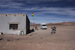
The little border crossing to Chile.

The little border crossing to Chile.

The border stuff for Chile you do in San Pedro de Atacama. Here:( S22° 54.666′ W68° 11.615′). BEWARE: you are not allowed to bring any fruits or seeds with you.

We did this route, and I didn’t have the feeling of missing something. I saw enough lagoons, and instead of the Arbol de Piedra we saw fantastic rock formations. But if you want to learn to ride sand you’d certainly should do the route 1.

GPX Tracks:

The tracks are found here:

http://www.wikiloc.com/wikiloc/view.do?id=8390836


Dust and colored lakes

Bolivias Southwest

Screen Shot 2014-11-30 at 10.44.13

The south of Bolivia is a wonderland for off-roading and landscapes. And of course we wouldn’t want to miss that.

I wrote a long report about this part of the trip. But I just realized I can’t express this in words.

We saw the most amazing places, rode fantastic dirt roads. The landscape was dusty, colorful, vast.

We suffered from the intense sun and the dust. We hit some sandy roads and got our feet wet in river crossings. We crossed the border at over 5000m.

We saw red, white and green lakes with flamingos. We saw mountains of green, red and yellow. We had chilly nights and strong winds.

We had a fantastic time.

Take a look at the pictures and enjoy.

Salt

It is unreal! I can feel the wind. I can feel the engine working hard underneath me. I feel the vibrations of the wheels spinning at 80km/h. I know I am riding a motorbike and I have it all cranked up. I go as fast as this 400ccm Honda dirt bike runs.

And still: I don’t seem to move.

I see the hexagonal shaped salt structures fly by and I know I am moving.

But the vast, completely flat, white and endless surface of the Salar doesn’t give my brain the usual information that we usually combine with moving. Everything that I can see except the ground seems to stand still. This place really plays tricks on your mind.

I am on the Salar de Uyuni.

It is the largest salt lake in the world and it is a magic place.

Screen Shot 2014-11-24 at 18.47.55

Originally we wanted to ride our bikes to one of the islands there and camp overnight. But we were unlucky with the weather. The evening before we wanted to go heavy rain softened the surface of the Salar. That is not a problem in terms of riding. But the salty water would get everywhere on the bike, causing problems everywhere, especially on the electronics.

We decided instead to rent some small 400ccm dirt bikes.

So the day after we rode our bike to MTB where Juan, our guide, was already waiting for us.

They have a really nice workshop there and a couple of different bikes.

We chose 400ccm Hondas and took off. We made a nice little loop on sandy roads to the eastern entrance of the salt lake.

Other than one would expect, you cannot enter the salt lake everywhere. There are only few entrances to the salt lake. Close to the land the salt surface gets very soft. Only few parts are solid. It is actually quite dangerous in some areas and a lot of people had to leave their bikes out there.

As we entered the Salar, we could see that large areas were covered in water. The salty water splashed over the bike, leaving a very thick rust of salt. You had to know the way very well. Once I got maybe 5m off the track and sank into the salt surface. I got out of the situation luckily by opening the throttle all the way.

On one of the little islands we had lunch. There are dozens of 4×4 standing around pouring hundreds of tourist on the little island. But that doesn’t reduce the magic of the place in any way.

In all directions it is white and flat. In the far distance you can see volcanoes that circle the salt lake.

The volcanoes are also one of the reasons why this is an important place for bolivian industry: the salt of the lake contains 70% of the worldwide lithium resources.

The surface is not entirely flat. When the salt had dried out some 20.000 years ago, it grew in hexagonal crystals which grew until the edges met each other. Water from underneath the salt lake moves up through these border lines, leaving salt crystals on the surface as the water vaporizes in the sun. The crystals stand out as high as 10cm, showing a pattern of hexagonal little walls as far as the eye can see.

Riding on the salt lake is like on tarmac. Not slippery as one could imagine. And it is great fun.

But we are happy we didn’t bring our own bikes. The small Hondas were covered in a thick salt layer.

We return to our little hotel after dark.

It was a perfect day and we need some time to allow the brain to accept that this place is real.

A dusty road and up the mountains

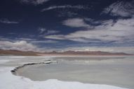
A little road leads all the way from Arequipa through the Salinas national park to Ouno at the Titicaca lake. It would be a pretty long way though and so we thought of instead take a daytrip with no luggage to a laguna in the Salinas NP. It turned out to be a great idea. First because the lake was really nice, and more importantly, we didn’t have any luggage with us: the road was a killer for being on the bikes.

Screen Shot 2014-11-14 at 23.33.47

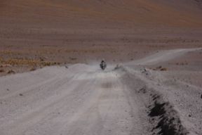
In endless curves it ran up a mountain. The road was one of the dustiest roads I have ever been on. In the curves the dust was 20cm deep with loose rocks underneath. So if you didn’t have enough speed your front wheel would slide and bounce from one side to the other. The only safe way beside speed was foot peddling through (Christies “powerwalk”).

We were covered in dust. But it was also a road of fantastic views.

Screen Shot 2014-11-14 at 20.58.52

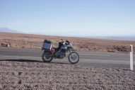
The next day we packed our bikes and took the main road to Puno. It was a great ride: good tarmac, a lot of Vacunas, Lamas and Alpacas, a wonderful landscape.


We enjoyed it a lot. It was very relaxing.